Home >
History, Geography, and Time
|
|
|
|
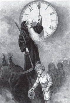
Father Time
A Pictorial Archive from Nineteenth-Century Sources. Mineola, NY:
Dover Publications, Inc.
|
|
Today, world history is a basic subject
in the social studies curriculum
across the United States. K12 educators
generally agree that young Americans
graduating from high school should have
knowledge of world history, geography,
and contemporary affairs. A world history
education should include the whole world
and not just part of it. The subject is
challenging, however, because it embraces
humanity in general, not just one nation
or cultural tradition, and because the time
scopefrom the Paleolithic era to the
presentis immense.
Getting the whole world into world
history does not mean that students must
investigate "everything," and certainly not everything all at once! To make sense of the past,
we have to organize the investigation into manageable pieces. We must define specific
historical topics, questions, problems, time periods, and themes, then explore them in
careful ways. Students, however, should not lose sight of the main subject: the story of how
humans have behaved, thought, and
interacted across the ages.
On this site, each of the Big Eras
addresses a time period on
the global scale. Each successive Big
Era is shorter in time scope than
the previous one. For example, Big Era One considers the very long epoch of history up to the emergence of Homo sapiens.
Big Era Nine, by contrast, focuses on the period from 1945 to the present. This
approach is generally compatible with conventional organization of courses, standards, and
textbooks. It also mirrors the long-term trend of historical change: human interrelations
have become increasingly complex, and the speed of change has continuously accelerated.
Consequently, recent Big Eras should encompass shorter time periods than more distant
ones if investigation of them is to be coherent and intelligible.
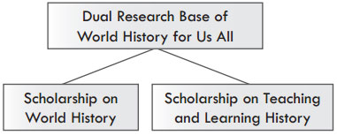
The World History for Us All model curriculum generally has a dual
research base. One is the exciting research in comparative, interregional, and world-scale
history that scholars have undertaken during the past several decades. This scholarship
has shown that although nation-states and civilizations are appropriate contexts for
studying historical change, other configurations of space and time are valid as well.
Patrick Manning has argued that the central aim of world history is to investigate
"the interaction of the pieces (be they community, societal, or continental) in human
history" and "to assess the experience of the whole of humanity through study of those
interactions."1 World history also involves searches for answers to questions about the
past that may lead the searcher straight across the boundaries of nations, empires, and
civilizations. World History for Us All has adopted the premise that when teachers and
students pose good historical questions, even very big questions, they can explore answers
in ways that charge their study with historical meaning and contemporary relevance. As
historian David Christian writes:
In a world with nuclear weapons and ecological problems that cross all
national borders, we desperately need to see humanity as a whole. Accounts of
the past that focus primarily on the divisions between nations, religions, and
cultures are beginning to look parochial and anachronisticeven dangerous.
So, it is not true that history becomes vacuous at large scales. Familiar objects
may vanish, but new and important objects and problems come into view.2
The other part of the World History for Us All research base is the work that scholars
in the United States, Britain, and other countries have done on the ways students learn,
interpret, and understand the past. They have been asking, "How do students build
meaning from historical information, and how do they connect facts to broader patterns
and generalizations?" These writers argue that historical understanding requires learning
of both the particular and the general. In fact, the ability to relate specific subject matter
to higher and more sophisticated levels of causation
and significance is a fundamental historical
thinking skill. Peter Lee has observed:
|
Children reading
A Pictorial Archive from Nineteenth-Century Sources. Mineola, NY:
Dover Publications, Inc.
|
|
While understanding something
in depth is a necessary part of
learning history ... it is not enough.
Moving from one in-depth topic
to another and illuminating each
one in the historical spotlight only
begins to develop historical understanding
if such topics are set in a wider historical
framework ... To provide something
students can use and think about, we may
need to teach a big picture quite quickly,
in a matter of two or three weeks, and
keep coming back to it. Such a framework
focuses on large-scale patterns of change,
encompassing students in-depth studies so
they are not simply isolated topics ... This means
students need to acquire a usable framework of the
past, a big picture organized by substantive concepts they increasingly
understand and can reflect upon.3
Scales of space and time
What is the best way to get started teaching and learning world history? In some
curriculums and textbooks, the first major topic is the agricultural revolution in the
Fertile Crescent in 12,000 BP (Before Present). In others, the first focus is the founding
of river valley civilization in Mesopotamia in 6,000 BP. In modern world history
courses, the first topic might be the Renaissance in Europe in the fifteenth and sixteenth
centuries. But what if we start, not at a particular spot on the globe, but with the world
as a whole? What if we think of the Earth as a "place" whose inhabitants have a shared
history? Events and developments may take place inside continents, regions, civilizations,
or nation-states, but those "spaces" remain parts of the globe in all its roundness.
Studying the past in this holistic way means asking questions about events and
developments that are relatively broad in space and time. In terms of geographical space,
study of the history of a rural community, a town, a city, a nation, an empire, a
civilization, the world, or even the universe are all valid. It is not that one geographical
scale of history is more important than another. Rather, at different scales we can identify
and ask different kinds of interesting historical questions. Where one scholar might
research 30 years in the history of a Mexican village to understand economic changes
there, another might take on migration patterns in Africa south of the Sahara from 1500
to 2000 CE. A third might explore 3,000 years of global climatic change and its effects
on human society. Students of world history may study very specific times and events, but
they may also try to understand them better by setting them in larger comparative,
regional, and global contexts.
We can push this point even farther. The Earth itself is framed by even larger
contextsthe solar system, the Milky Way galaxy, and the universe. As we explore how
human beings evolved, acquired mental abilities that no other animal species possessed,
and came to populate almost all parts of the world, we should remember that when our
species emerged, the Earth had already existed for more than four billion years. Complex
processes of physical and biological change had long been underway when our first
bipedal
ancestors appeared on the scene just seven million years ago.
Learning to "think the world"
One of the wonders of our era is that for the first time in history, people everywhere
in the world can experience the same event almost simultaneously. A spectacular example
of this is the world-wide celebrations that greeted the New Year in 2000. The planet
revolved through the time zones, midnight struck again and again, and the festivities
broke out in rapid, rolling sequence around the planet. Among the first to celebrate were
the people of the Kiribati and Marshall Islands, which lie in the South Pacific just west of
the International Date Line. From there, the New Year swept on to Sydney, Beijing, New
Delhi, Jerusalem, Lagos, London, Caracas, Seattle, and, at last, Honolulu. Those who
had the stamina to watch TV long enough could see the entire relay of parties, prayers,
and fireworks displays, for twenty-four straight hours. This spectacle was a compelling
reminder of the unity of humankind as inhabitants of a single tiny "marble" suspended in
the universe. Also remarkable is that millions of people could consciously witness the
world-wide commemoration and reflect upon it in real time.
Electronic marvels invented in
the twentieth century enabled men
and women to "think the world" in
a way that no one could have done
in 1000 CE or even in 1900.4
We live now in what scholars have called
a "condition of globality." Careers,
family life, community activities,
and even mental health all depend to
some degree on our understanding
of the astonishing complexities that
intertwine all human beings. The
ability to "think the world"its
economy, science, technology, politics,
and culturemust be a primary aim
of all education today. This challenges
us to rethink humanitys history in a more holistic, interconnected way.
Millions of young people around the world spend their typical dayswhen not
looking at a computer screen or talking into a cell phonecongregating with family
members, fellow students, friends, or coworkers. But those bonds are only our most
special. We are also connected, often unconsciously, to numerous other networks of human
relationships that affect the course of daily life. Some of these "communities" may be
fleeting (passengers sharing an airplane flying at 30,000 feet), and some may be very large
(all members of the Roman Catholic Church). Some of them cut across many generations,
such as family trees, or the communities formed by particular religions or nations. No
individual anywhere in the world is truly isolated from such complex global relationships,
not hunters in the Amazon rain forest, nor peasant girls in high Himalayan valleys.
In fact, most people are continuously affected by events and trends initiated in
distant parts of the globe. Supermarkets in Wisconsin raise the price of coffee because
of weather conditions in Brazil. An office conference call gets cut off, causing minor
panic over a deal closure in Beijing. Or, on a very big scale, house prices in the United
States drastically drop, triggering a chain of events that ends in a world recession! Our
continuous encounters with the wide, wide world are an aspect of the dizzying pace of
change, the single most conspicuous feature
of contemporary life. Whether in the
United States, Italy, Burma, or Swaziland,
society is perpetually transforming itself
because of the growing complexity of world
communication, the flow of goods and
financial transactions, and the apparently
never-ending birth of new ideas, techniques,
and products.
|
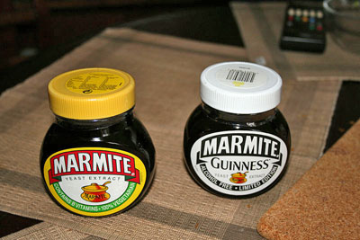
Marmite is a yeast paste loved by British childrenbut not by Americans.
Wikimedia Commons
|
|
Our culture, that is, our language,
institutions, laws, moral codes, and regular
social routines, buffers us to some extent against the gales of change. Shared culture
enables people to have some expectation of how others will think and behave. It helps
us predict with at least some accuracy the shape of our affairs from one day to the next.
In so far as we have a place in a familiar system of cultural values and organizations, we
can usually cope quite well with new things or sudden change. When a social groupa
family, religious denomination, business community, or nationconfronts something
new or foreign, its members try to fit the strange thing into the existing cultural system
with a minimum amount of fuss. Or the group may reject it altogether as useless or
distasteful. So far, for example, American children have stoutly resisted Marmite, the
yeast paste that British children love to spread on bread. And not everyone in the world
likes peanut butter. On the whole, social groups do well at using their cultural yardsticks
to sift through the new and strange, accepting one item, rejecting another, so that life
does not appear to change all that much from one month to the next.
Yet in todays globally interconnected world, the forces of change, ricocheting around
the world, are much more encompassing than we generally realize or wish to believe.
Global change is not simply a matter of one event there (war in the Middle East) affecting
some condition of life here (a rise in the price of gas). Nor is it just that products or ideas
spread quickly from one place to another. The most striking feature of global interaction
is that a significant development occurring in one place is likely to set off a complex
chain reaction, disrupting and rearranging numerous relationships over an extensive area,
maybe even around the world.
When did the world get like this? For how long have peoples of the globe been
interconnected? Since the Industrial Revolution? Since World War II? Since the invention
of the Internet? A better question might be: How far back in time would we have to
go to find a world divided into a collection of entirely separate, self-contained societies,
each moving through time along its own track, unresponsive to developments anywhere
else? The answer is that we could cast back two hundred, five thousand, twenty thousand
years and still not find such a world of completely atomized societies. Indeed, even the
early history of humankind hundreds of thousands of years ago is a story of long-distance
migrations of hunting and foraging bands across Africa and Eurasia, a process that
involved interaction between one group and another wherever such contact took place.
Some important geographical terms
To "think world history" in a way that makes room for all peoples requires that we see
the spherical surface of the planet as the primary place where history happened. Students
need, therefore, to have a basic knowledge of what the World History for Us All model
curriculum has called Big Geography, that is, the largest-scale features of the earths
physical and natural environment. These are the patterns of topography, vegetation,
climate, and weather that cut across particular nations or cultural groups and that give
the world as a whole its distinctive "face." Attention to Big Geography prepares students
to explore particular events, time periods, and regions in a way that encourages making
connections between whatever subject matter they are learning and the world-scale
context. This site uses some geographical terms that may not be familiar to teachers
and students.
Afroeurasia
Afroeurasia is the landmass made up of Africa and Eurasia together. Afroeurasia
was formed during the last 40 million years by the collision of the tectonic plates that
contained Eurasia and those that contained Africa and Arabia. This geographical
expression serves as a helpful tool in discussing large-scale historical developments that
cut across the traditionally-defined continental divisions of Africa, Asia, and Europe.
Even though Africa is separated from both Europe and Asia by the Mediterranean and
Red seas (except at the Isthmus of Sinai where modern Egypt meets Israel), these bodies
of water have historically been channels of human intercommunication, not barriers
to it. Therefore, we may think of both the Mediterranean and the Red Sea as "lakes"
inside Afroeurasia.
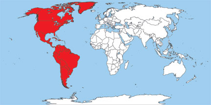
America, the Americas
The Americas are made up of the continents of North America and South America,
including neighboring islands, notably the islands of the Caribbean Sea. Until the
twentieth century, most geography books classified North and South America together as
a single continent, labeling them the "New World" ("new" to Europeans beginning in the
late fifteenth century CE) in contradistinction to the "Old World," that is, Afroeurasia.
In the twentieth century, school children in the United States and most other countries
(though not in some Latin American states) were taught to see the "Western Hemisphere"
as constituting two continents, joined only by the narrow Isthmus of Panama. On the
other hand, humans in North and South America have never been entirely disconnected
from one another. As far as we know, humans first migrated from North to South
America 12,000 years or longer ago by advancing along either the Isthmus or its coastal
waters. Also, it is not hard to perceive the Gulf of Mexico and the Caribbean Sea as
two "internal seas" of a single American landmass, much the way we may think of the
Mediterranean and Red seas as "inside" Afroeurasia. The Caribbean and the Gulf of
Mexico are bounded on three sides by land and on the west by a long string of closely
clustered islands.
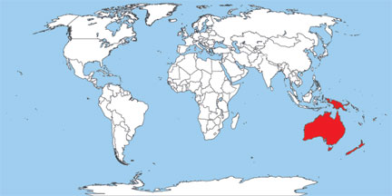
Australasia
The continent of Australia, plus New Guinea, New Zealand, Tasmania, and other
islands that neighbor Australia make up Australasia. During the last Ice Age, when sea
levels were lower, Australia, New Guinea, and Tasmania constituted a single landmass
known as Sahul. Human settlement of Australasia began as many as 60,000 years ago,
though Polynesian mariners did not reach New Zealand until about 1000 CE.
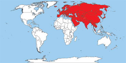
Eurasia
Eurasia is the landmass made up of Asia and Europe. Today, this term is widely
used in history and geography education. The idea that Europe and Asia are separate
continents goes back many centuries, but scholars who accept the definition of a
continent as "a large landmass surrounded, or nearly surrounded, by water" know that the
definition applies to neither Europe nor Asia because these two landmasses are conjoined.
Moreover, the Ural Mountains, which eighteenth-century European geographers
designated as the proper boundary between the European and Asian continents, have
never been a serious obstacle to the flow of migrants, armies, trade goods, or ideas. On this
site, we define Europe as a subcontinent of Eurasia (or of Afroeurasia), parallel to South
Asia or to the Indochinese peninsula.
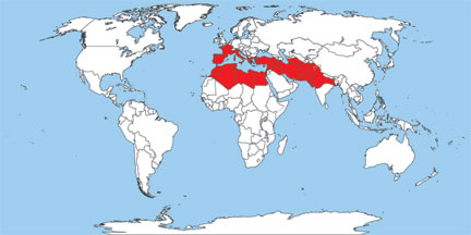
Great Arid Zone
A climatic map of Afroeurasia shows that a good part of the landmass is a belt of
dry or semi-dry country that extends all the way from the Atlantic coast of Africa in a
generally northeasterly direction to the northern interior of China. This enormous tract
comprises a chain of interconnected deserts, mountains, and semi-arid steppes. A steppe
may be defined as flat or rolling grassland, equivalent to what Americans call "prairie"
and Argentineans call "pampas." The main climatic characteristic of the Great Arid
Zone is low annual rainfall, which may range from an average of less than 5 inches in
the bleakest of deserts to 20 inches or so in better watered steppes. For several millennia,
the Great Arid Zone has been home to pastoral nomadic peoples. Where water has been
available from rivers, springs, or wells, it has also been home to farming societies and
even large cities.
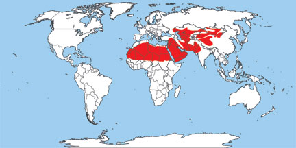
Indo-Mediterranea
The region of lands and seas extending from the Atlantic coasts of Europe and
North Africa to North India is known as Indo-Mediterranea. This expression includes
the Mediterranean basin as a whole and extends eastward across Southwest Asia to
northern India as far as the Bay of Bengal. In the long term of human history from at
least the third millennium BCE to modern times, this region has been characterized
by a proliferation of clusters of dense population (notably in river valleys) and by intense
commercial and cultural interchange.
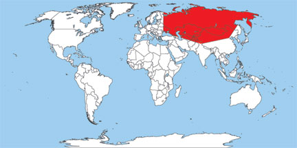
Inner Eurasia
The huge interior landmass of Eurasia, whose dominant features are flat, semi-arid
regions of steppe and forest, is known as Inner Eurasia. David Christian defines Inner
Eurasia as the territories ruled by the Soviet Union before its collapse, together with
Mongolia and parts of western China. Poland and Hungary on the west and Manchuria
(northeastern China) on the east may be thought of as Inner Eurasias borderlands. The
northern margins are boreal forest and Arctic tundra. The southern boundaries are the
Himalayas and other mountain chains.
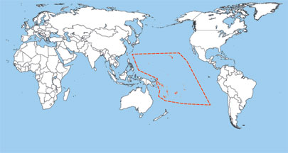
Oceania
The basin of the Pacific Ocean and its approximately 25,000 islands make up
Oceania. Human settlement of this enormous region, sometimes called the Island Pacific,
began in western islands near New Guinea about 1600 BCE. Polynesian mariners
reached both Hawaii to the northeast and Easter Island to the far southeast around
500 CE. The majority of the islands lie in the tropical belt south of the Equator. The first
peoples of Oceania spoke mostly Polynesian languages. Some geographers include both
the large island of New Guinea and the continent of Australia as part of Oceania.
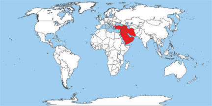
Southwest Asia
Southwest Asia is the designation of the region, often referred to as the Middle East,
which extends from the eastern coast of the Mediterranean Sea to Afghanistan, including
Turkey and the Arabian Peninsula, but not including Egypt or any other part of Africa.
World History for Us All uses the term "Middle East" only in the context of history
since the start of the twentieth century. For earlier periods, "Middle East" has caused
students of history considerable confusion because it is used sometimes as a synonym for
Southwest Asia, sometimes to encompass Southwest Asia plus Egypt, and sometimes to
embrace the entire region from Afghanistan to Morocco.
PowerPoint Presentation: Big Geography
Teaching Units for History, Geography, and Time 

Footnotes:
Note:
Documents in Portable Document Format (PDF) require Adobe Acrobat Reader 5.0 or higher to view, download Adobe Acrobat Reader.
Documents in Powerpoint format (PPT) require Microsoft Viewer, download powerpoint.
Documents in OpenOffice format (ODT) require Oracle OpenOffice, download Oracle OpenOffice.
Documents in Word format (DOC) require Microsoft Viewer, download word.
|